The Dorset Walk – The South Winterborne
Teresa Rabbetts follows the pure waters of a winter river down its valley
Published in October ’17
Humans have settled by water since time immemorial – initially to ensure they were provided with the most basic needs such as fresh drinking water, a source of food, washing, cleaning and the prevention of disease, whilst in more modern times river water has driven innovation and powered mills, machinery and transportation. Small communities endured and flourished thanks to the river by which their ancestors established themselves, expanding over time into towns and cities. In contrast, rural settlements are viewed in a more idealised way as having been mythically peaceful, romantic and unspoilt places that endure, largely unchanged. However, the reality is that scores of villages were abandoned after a struggle for existence.

Came House, Georgian masterpiece built by Francis Cartwright for John Damer
Dorset has had its fair share of settlements that declined and were subsequently deserted: plague epidemics decimated populations; landscapes were re-created, for example en route to the creation of an ‘authentic’ countryside; communities were sacrificed to satisfy a landowner’s vision for landscaped parkland; villages were vacated to provide pasture for sheep; sometimes they simply proved to be too remote to be sustained, particularly as Turnpike Trusts scheduled new routes across the countryside, laying down the template for modern roads.
South of the Dorset’s more famed River Frome, the South Winterborne is a small, secretive water which meanders quietly through chalk, flowing by banks and chronicling stories which were less than idyllic and reveals that its riverside settlements faced a series of threats from sources which resulted in their extinction.
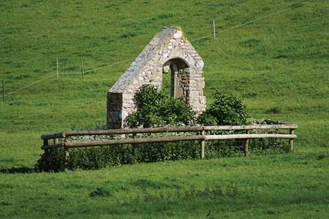
The reconstructed remains of St German’s (or Germain’s) Church at Winterborne Farringdon
Winterbourne streams are special, providing a unique habitat for rare wildlife. Found in various chalk areas across the southern part of Britain, winterbournes (from the Saxon word for a stream flowing from a spring) are fed by ground-water which is held in the chalk; the water filters through chalk, providing perfect conditions for wildlife, as not only is the water crystal-clear but it is maintained at a relatively constant temperature. As it bubbles up in springtime, it feeds the streams and then decreases, sometimes stopping during dry periods when the water table drops below the level of the stream-bed. When the water table is re-charged, heavy rainfall frequently provides more water than the usually gentle streams can manage, leading to heavy flooding.
Rising at springs in Winterbourne Abbas, the South Winterborne (note the confusion in spellings; I have followed the Ordnance Survey versions) flows quietly through an ancient landscape, passing Winterbourne Steepleton with its medieval spired church and accompanying the B3159 through Winterborne St Martin before running alongside Maiden Castle and the sparsely populated Winterborne Monkton. Dipping under the Roman Road (now the busy A354) to the coast, the stream continues by landscape that, despite being so close to Dorchester, is peaceful and largely forgotten.
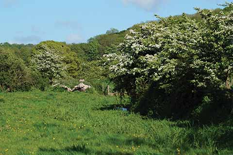
In spring the walk is a riot of greenery, in autumn and winter the views open up
Originally named Winterborne Beauchamp and then variously Wynterbourn and Winterborne Harange before settling on Winterborne Herringston, the small parish and manor was named after the family who were granted it in the 13th century. Although it is often referred to as a village, in fact no evidence of a church or other buildings is evident. The principal building at Herringston seems to have always been the unique manor house, at one point described as a fortified manor house. Walterus Heryng de Winterborne was granted a licence in 1336 by Edward III to crenellate his manor house, but this was unlikely to have been a real defence or fortification, more likely a symbolic way to demonstrate his wealth and rank, a prestigious display to show off the fact that Walter was recognised by the monarch. What remains of Walter’s house today is much altered, having been remodelled over subsequent centuries.
Coker’s Survey of Dorsetshire, 1732, the first book published to exclusively give an account of Dorset (although the writing of which is likely to pre-date the publication by at least a hundred years), mentions lost settlements along the Winterborne: Winterborne Afbton, where ‘there is not one House remaining’ and Winterborne Harange, ‘the Seate in former Ages of the antient Familie of Harangs’. The author goes on to attribute the de-population of Farendon, which was barely a stone’s throw to the east of Herringston, to the ‘Covetoufneffe of fome private Men, that to encreafe their Demefnes have depopulated whole Parifhes’ (the covetousness of some private men, that to increase their demesnes have depopulated whole parishes).
Originally named for its church and recorded as Winterborne Germain in the 13th century, it became Farringdon after the 14th-century owners. Sadly, the history of this settlement has been lost and by the time documents were being preserved, Farringdon was a village that had been struggling to retain its existence for several generations. 1428 records show that it was excluded from taxation on the basis that there were too few inhabitants and the Hearth Tax Returns of 1662 cite three houses at Winterborne Herringston and two in Winterborne Came but record Winterborne Farringdon as deserted. By 1774, when Hutchins wrote of the county in The History and Antiquities of the County of Dorset, he refers to the village as ‘entirely depopulated and has been so beyond the memory of man’. Today, apart from the name, the only remnants of Winterborne Farringdon are earthworks and holloways and a small stretch of St Germain church wall, although that is a re-built section.

You may not be the only inquisitive walker on the route
The Enclosure Acts of 1773 and 1801 massively impacted on rural life in Britain, enabling landowners not only to fence off land and remove the right of commoners to access it, but also to charge higher rents to people working the land. The Winterborne valley saw even earlier attempts to restrict tenants, which may account for the desertion of settlements across the vicinity. In 1521, tenants of Sir William Fyllol, owner of Winterborne Came, complained that their lands were over-run by his sheep; they made suit to the Court of the Star Chamber claiming that ‘because of the greate oppressions and injuries’ they would not be able to pay their rent ‘nor be Able to Abide in their country by cause of the saide greate oppressions’.
Landscaped parks have provided us with a quintessential view of the rolling English countryside; however, this scene is something of a creation. As ‘new wealth’ appeared amongst the 18th-century aristocracy, they displayed wealth ostentatiously by making their mark on the landscape. Came House is a fine example. Built in gleaming Portland stone in 1754 for John Damer, it sits on rising ground and epitomises the popular Palladian country house design of the time – designed to catch the eye of travellers on what was then the route into Dorchester, with obvious displays of the Damer arms.
Continuing eastwards, the South Winterborne leaves the Winterborne valley, gradually losing its individual identity to join a series of drains and sluices while passing by West Stafford before finally uniting with the River Frome.
THE WALK
1 Leaving the start, head towards Higher Came Farm and follow the signpost beyond the house which indicates left. Continue through the area of farm buildings until the path leaves the farm behind and rises uphill towards the tree line, which is South Plantation, and then proceed downhill, passing Keepers Cottages on the right. The path continues to descend towards Came Park, with Cole Hill Wood on the right, glimpses of the rear of Came House and passing cottages on the left. The path joins a track from the left. Follow the route right and over the South Winterborne to a junction at the tarmac road.
2 Turn left at the junction and walk along the road, passing in front of Came House – the field on the right of the front of Came House is the former site of Winterborne Came village. Continue along the road, passing a tree-lined hedgerow leading to Home Wood; the former site of Winterborne Farringdon is in the next three fields with the remains of St Germain’s Church in front of Chapel Hill Coppice.
3 Continue along the road, passing the turning to Herringston Dairy House on the right and the lane passes over the South Winterborne again eventually coming to a junction opposite Winterborne Herringston. Turn left and follow the road back to the starting point. Proceed with care on the final stretch – this road can be quite fast and busy. To avoid walking in the road, use the wide verge on the far side of the road.
Parking & start: From the A354 Dorchester to Weymouth road, turn left to Came Down Golf Course. The road passes under the railway bridge to a turning. Turn right, keep Herringston House and gardens on the right, round a sharp right-hand bend and follow the road to the sharp left-hand bend which goes along the bottom of Came Down Golf Course. Park carefully on the roadside by the sign and junction to Higher Came Farm (just before the road begins to rise up towards Ridge Hill). The route begins by walking towards Higher Came Farm.
Terrain: Easy terrain – entire route on gravel track and tarmac road.
Distance: 2 ½ miles
Maps: OS Leisure 15 Purbeck & South Dorset.


