The Dorset walk 1: The other end of Portland
Matt Wilkinson and Andy Farrer look down on East and West Weares
Published in April ’17
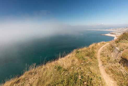
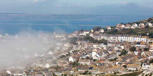
Looking north as a light sea mist rolls in from the west
Mention Portland and most people will probably picture Portland Bill with its red-banded lighthouse and its wild weather. But the northern half of Portland, where the island bulges out rather buxomly before narrowing to the Bill, has at least as much to offer. In fact this route includes five of the island’s main features: the sea, quarrying, the military connection, the burgeoning arts scene – and prisons.
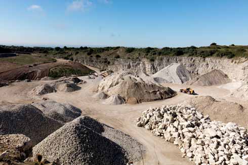
Portland’s quarrying past as well as its military connections (below) are explored on this walk
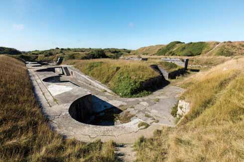
High Angle Battery
The dangerous waters around Portland have always provided a living for its fishermen and, in bygone days, for its smugglers – sometimes one and the same. This walk takes in the coast on both sides of the island, above the wild foreshores known as East and West Weares.
Stone from Portland has been used by architects from Wren (to face St Paul’s Cathedral) to Lutyens (to build the Cenotaph) and the walk passes still-active quarries. Watching the huge moving machinery used today increases one’s admiration for the quarrymen of old, who had only hand-operated cranes and jacks to help them.
The walk passes the High Angle Battery, built in 1892 to fire shells like a howitzer, high up into the air to drop onto the decks of ships. All ships by this time were iron-clad, and the theory was that their decks were their most vulnerable surface. The batteries had a comparatively short life, being decommissioned in 1906, but the position of the six guns, which were reckoned to be effective at a range of up to six miles, can still be clearly seen.
More and more artists are finding the particular atmosphere of Portland beneficial to their creative skills and the walk passes several studios. Its last stretch is through the Tout Quarries Sculpture Park, where sculptures by the likes of Anthony Gormley, Barbara Ash and Jonathan Sells inspire students making their first tentative chips from a piece of Portland stone on one of the courses run in the park by the Portland Sculpture and Quarry Trust.
The Verne Citadel is located on the highest point of Portland and was built between 1857 and 1881 as part of the defences of Portland Harbour. When the Army left in 1949, it became HM Prison The Verne and is now an Immigration Removal Centre. The prison at the Grove opened in 1848 as Portland Prison. It was converted to a Borstal in 1921 and became a Young Offenders Institution in 1988. In 2011 it reverted to its original use and name as a youth and adult prison.
Distance: About 5 miles
Terrain: Generally good, although the path up the western side of the island is rough and rocky in places. No major climbs.
Start: In the car park to the east of Verne Yates. OS reference SY691732. Postcode (approx.) DT5 2EN.
How to get there: Follow the A354 onto Portland and through Fortuneswell. At the roundabout at the very top of the hill out of Fortuneswell, turn left, bear right and pass an obelisk on the left. The car park is on the left.
Maps: OS Explorer OL15 (Purbeck & South Dorset), OS Landranger 194 (Dorchester & Weymouth).
Refreshments: The Heights Hotel.
THE WALK
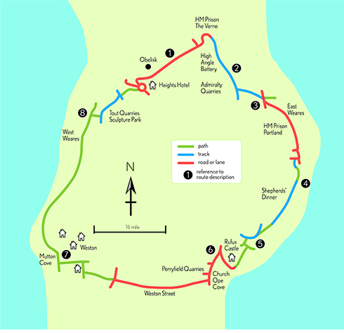
1 Continue along the road in the same direction or rather, continue along the fence on the left to enjoy the best of the view. Where the road bends very sharply to the left, downhill, carry straight on, signed to HM Prison The Verne, High Angle Batteries and East Cliff. Follow the lane round to the right in front of the entrance to the prison, and continue in the same direction along a rough track. The High Angle Battery on the right is worth a brief detour.
2 Then stay on the track towards what looks like a minaret but in fact is the side view of a bell-cote. Over the bank to the right are the massive Admiralty Quarries, which are still being worked. Ignore a number of paths running off to the left and stay on the main track until it meets a definite fork. Here turn left to reach a paved road. Cross this towards the cliff-top on the left, where there is an information board but also a fabulous view down to the Breakwater and across to the coast stretching eastwards all the way to St Aldhelm’s Head.
Looking northeast across Portland Harbour towards the breakwater and Weymouth Bay beyond
3 Return to the road and turn left, then bear left to the fence of HM Prison Portland. Turn left to walk down a road right next to the fence, turning right at the end of it. Continue with the fence or wall of the prison on the right and the rather more attractive view over the sea on the left. Eventually the road curves away to the right, but continue ahead, towards a radio mast. Just in front of the mast, turn right, and at the end of a short stretch of road, left onto a track. Follow the track into an open area, where follow the wall on the left to a gateway with a kissing gate on the left.
4 Go through this onto a path that soon opens up into a track. Follow this, staying close to the edge of the cliff, which is unfenced in places – so take care and keep children and dogs under close control. This area is known by the delightful name of Shepherds’ Dinner, although its origin is unexplained. A view of the southern end of Portland opens up: the Bill, the lighthouses and Southwell with its starkly square business park that was once the Admiralty Underwater Weapons Establishment, home of the Portland spy ring of the 1950s. The track narrows to a path but then meets a wider track again. Continue to follow this in the same direction until it bends to the right and goes downhill.
5 Here climb over the bank straight ahead, cross a small open area, go through a metal gate and turn immediately left onto a narrow path. This is enclosed at first but opens out and reaches a junction where another path doubles back to the right, downhill. Take this path, which emerges under the walls of Rufus Castle, with Church Ope Cove below. Turn right on a lane up the side of the castle and under a bridge to emerge on the main road by Portland Museum (open 10.30-4, Saturday-Thursday, during the summer).
6 Turn left and walk down to the third turning on the right, Weston Street. Perryfield Quarries are on the right. Follow Weston Street all the way to its junction with a main road. Go straight across and along a path to the right of Weston Community Hall. At a T-junction of paths turn right and at the top of this path turn left to reach the west coast of the island above another splendid name: Mutton Cove.
7 Turn right on the path that runs along the cliff-top – again mostly unfenced, so care is needed. Now the view is across Lyme Bay to the Devon coast. This path is sometimes closed by rock falls, in which case brief inland diversions are usually well waymarked. It is actually worth making such diversions off your own bat, even if they are unnecessary, to marvel at the bizarre quarrying landscape and the range of unusual and attractive wildflowers that have colonised the old stone workings.
8 About a mile after joining the path, reach two great defiles made of enormous blocks of stone. Just before the second one, climb up the bank on the right and walk inland, into Tout Quarries Sculpture Park. Reach a broad track and turn left. Follow the track through the sculpture park – with diversions to admire the sculptures, no doubt – until it reaches a T-junction. Here, scramble up the steep slope ahead and bear slightly right at the top. Stay on the high ground, heading towards the Heights Hotel and the obelisk which is Portland’s war memorial. Arrive at a roundabout and take the road that leads between the war memorial and the hotel to reach your car.


