The Dorset walk 2: Bourton
Teresa Rabbetts goes to the north of the county
Published in April ’17
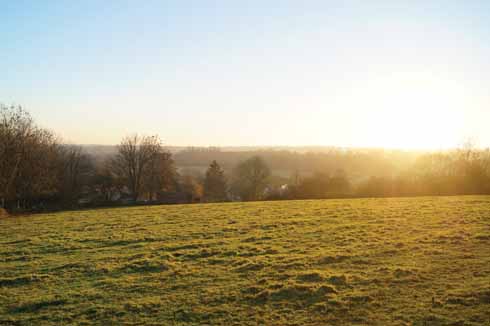
North Dorset has more than its fair share of open vistas
At the top edge of the Blackmore Vale, bordering Somerset and Wiltshire, sits Bourton. It is the most northerly village in Dorset and, although overshadowed by more famed attractions in the county, its position on steep slopes makes the village worth exploring as it enjoys far-reaching views towards Shaftesbury, Duncliffe Wood, Mere Downs and beyond.
The direct route from London to Exeter travelled through Bourton lanes which, until the 19th century, were little more than narrow, ancient trails; however, increasing coach traffic necessitated the construction of new roads and in 1823 the first ‘quicksilver’ mail coaches travelled through Bourton on the imaginatively named ‘New Road’ and Bourton Bridge, making the village an important staging post and necessitating the provision of stabling for horses and accommodation for travellers. The early part of the 20th century required further changes to the roads as the use of the motor car grew and then again, after many years of surveys and consultations, the parish was dissected by the A303 bypass in 1992, separating Bourton from the hamlet of West Bourton.

It’s only a short walk, so you’ll never be more than 3 miles from the pub wherever you are along the route
Standing by the Stour, the livelihood of Bourton residents was long principally based on the river – milling and the cottage industry of flax processing and spinning were significant for many generations; however, the Industrial Revolution deeply affected cottage industries and as industrial spinning processes were developed during the 18th century, mills took over from cottage industry production. For a period, scores of families migrated from Dorset in search of work, many finding themselves in the rapidly growing coal mines and steel works of South Wales.
By the 19th century, the villagers that remained found themselves employed in Bourton Mills which became a key centre of employment for the area (reputedly three-quarters of the population of Bourton was involved in millwork in 1811). Daniel Maggs ran a mill which processed and span flax for the linen industry, supplying sailcloth to the British and Russian navies until the 1860s, when trade significantly declined due to fierce competition from factories in the north of England. Nearby downstream, William Jesse built a factory which produced a rugged, durable cloth from linen and wool known as Linsey-woolsey and had a large blacksmith shop. A few years later, when Oliver Maggs established a new mill, he took over Jesse’s blacksmith shop and established a foundry where he produced agricultural implements and a spectacular 60-feet iron waterwheel for the mill, which remained a famous landmark until it was demolished in the 20th century.
As the flax mill became redundant, Edmund Hindley, an engineer, millwright and iron founder, purchased Bourton Foundry, producing a range of products from the 1860s including steam lorries, oil and gas engines, pumps, dynamos, hoists and saw benches which were exported throughout the world. This began unexpectedly heavy industrial production in a small Dorset location which continued for the next fifty years.
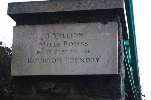
Bourton was once a centre of grenade, or Mills bomb, manufacture
During World War 1 the premises became a munitions factory and produced casings for Mills bombs (a type of hand grenade) in vast quantities – more than three million. Nature brought about an end to wartime production when in June 1917 southern England found itself under a ferocious band of thundery rain and the Gasper dam, which is situated upriver near Stourton, was unable to cope with the thousand tons of water running into it from the surrounding hills. It burst and a raging torrent poured down the Stour, washing away two further 18th-century dams together with anything in its path. Downriver, after the flood cascaded through Bourton Mill, the Western Gazette reported: ‘Many parts of the works were flooded to a depth of from five feet to ten feet. In the clerical department a large safe and its contents, estimated to weigh from 15 cwt to a ton, was over-turned…. The caretaker lost a lot of his furniture, and made his escape from the house by means of the roof.’ Thankfully there was no loss of life, but the foundry was severely flooded: walls were washed away, heavy machinery not just damaged but actually uprooted and moved.
When in 1918 the famed large waterwheel was scrapped – the metal presumably used for the War effort – heavy industry finally ceased on the site, although small production of units for the shipbuilding industry continued until 1927.
The final phase of Bourton Mill’s history saw the premises became a processing plant for milk products, firstly for Farma Cream Co and then becoming United Dairies, Cow and Gate before finally being run by Unigate until 1984. The mill and foundry buildings now stand in atmospheric dereliction; ‘For sale’ signs scattered along the roadside suggest that the next phase in the future of the site will see residential development.
How to get there: From Shaftesbury take the B3081 to Gillingham. At Gillingham follow the signs for Bourton.
Parking & start: Turn off New Road which runs through the centre of Bourton just before the War Memorial and St George’s Church, park in West Bourton Road. The walk begins in Brickyard Lane which is opposite the War Memorial just as you turn into West Bourton Road.
Terrain: Varied. Steady climb in some parts; a mixture of green lanes, tracks and road – seasonally very muddy stretches.
Distance: 3 miles.
Maps: OS Landranger 183 Yeovil & Frome, OS Explorer 142 Shepton Mallet & Mendip Hills.
Refreshments: White Lion Inn, High Street, Bourton
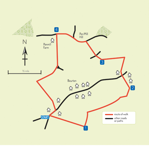
THE WALK
1 From the War Memorial the route begins by walking down Brickyard Lane past the electricity sub-station and then turn left passing through a gateway. The path is a green lane with hedgerows on either side – continue to the end of the lane and turn right onto Clay Lane (the route is indicated by a yellow arrow on a Public Footpath marker). Climb the stile and follow the path diagonally across the middle of the field and the route descends to a ford – there is an iron bridge to cross and follow the path as it becomes a tarmac lane and passes Mill Cottage and up Mill Lane.
2 At the end of Mill Lane turn left into Silton Road. At the end of Silton Road turn left and walk to the crossroads. Cross the road to High Street – the White Lion Inn is just round the corner. Walk uphill past the White Lion Inn and opposite Bourton House go through the kissing gate and follow the path diagonally uphill across the field to another kissing gate in the far corner.
3 The grass path now continues downhill, passing through the gate and straight across the road (Factory Road) – this looks like the entrance to a house but the route turns off right just before the iron-gate entrance to Bullpits. Just before the gates turn right and climb up railway sleeper steps and through the gate and then turn immediately left. The route now runs along the bottom of the golf course to another gate with a road beyond (Pen Mill Hill). Turn left and follow Pen Mill Hill downhill.
4 Walk past Penselwood Pumping Station (on the right) and opposite the letterbox turn left (signposted to Bourton). Go through the gate and past Penmill Farm and pond on the right. Continue to the top of the hill to Kite’s Nest Cottage and turn right to follow the green lane which is Long Lane (originally the Post Road – London to Exeter, but now the boundary between Dorset, Wiltshire and Somerset). Then turn left back to Bourton as the path continues downhill through kissing gates with Primrose Farm on the left and rejoins New Road, turn right to return to the start of the walk.


