The Dorset Walk – Milton on Stour and Silton
Matt Wilkinson and Andy Farrer near the county’s northern border
Published in September ’16
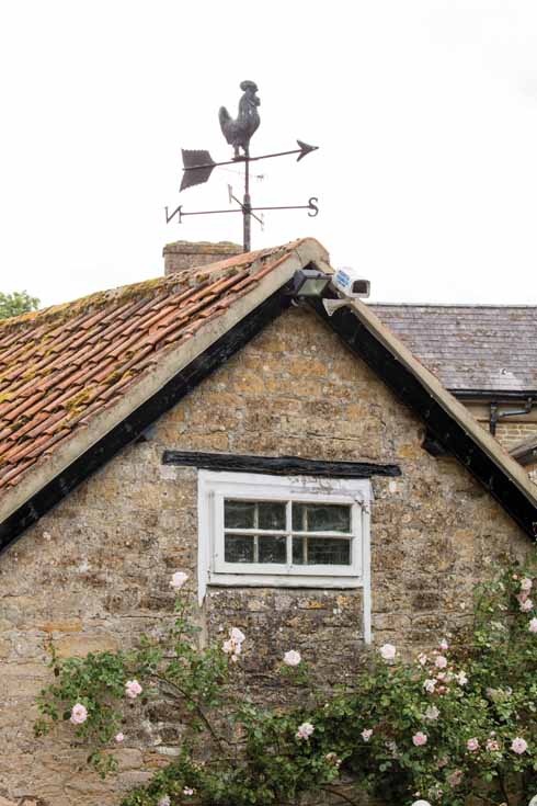
When you see this handsome weathercock on the right, turn left
Milton on Stour and Silton are two of the settlements closest to the source of the River Stour at Stourhead, where it starts its sixty-mile journey to the sea. Here it is less of a river and more of a healthy stream, very different from the broad waterway that flows through Blandford and round Wimborne and Bournemouth on its way to the sea at Christchurch Harbour.

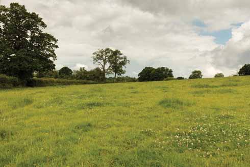
The ‘young’ River Stour near its northern source lacks the fast fluvial flow of its mature mill-powering self further downstream
The walk passes close to Purns Mill, which is actually not on the Stour but on Shreen Water, one of the three rivers that flow through or near Gillingham, the Lodden being the third. An earlier mill on the site was painted by John Constable several times, most notably in 1826, but burnt down soon afterwards.
Pasture before Wyndham’s Oak
The route crosses the Stour near Milton on Stour, which was given to Catherine of Aragon on her marriage to Henry VIII. The church of St Simon and St Jude is 19th-century, paid for largely by the Gillingham brewers, the Matthews family. The fixtures and fittings are in the style of Sir George Gilbert Scott, and also A W Pugin, both of whom worked in the area. The decorated roof vaulting is characteristic of their style. William Taft, President of the USA from 1909 to 1912, was descended from a Milton on Stour family.

The massive and ancient oak tree known as Wyndham’s Oak was big and interesting enough to have been the subject of an engraving in the 18th century and may well already have been 800 years old when that image was created
In Silton, the name of Sir Hugh Wyndham lives on in Wyndham’s Oak, which is claimed to be 1000 years old. He was a judge under Charles I, Cromwell and Charles II, despite being briefly imprisoned at the Restoration in 1660. He died in 1684 in Norwich while acting as a circuit judge, but his body was brought home to Silton, where the interior of the church of St Nicholas is dominated by an elaborate memorial to him.
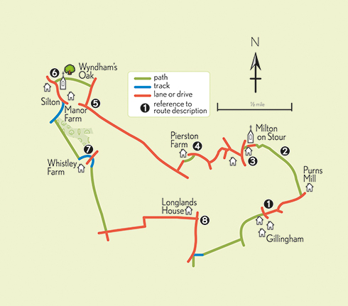
THE WALK
1 Walk on down the lane and follow it round to the left and right. About 50 yards before the lane ends at Purns Mill, just before a rather handsome weathercock on the right, go left through a metal gate and bear right to a double stile on the other side of the field. Bear slightly left in the next field to an opening clearly visible on the far side and continue in the same direction across a third field.
2 In the field after that, bear left to its far left-hand corner, in front of a long single-storey building to the right of the steeple of the parish church. Cross a double stile into a small grassed area and go through a metal gate in its far right-hand corner. Walk down to a lane and turn left. Continue ahead, between the primary school and the church, to reach a road. Turn left and cross over to walk down the pavement to the first turning on the right, signed to Zeals and Bourton.
3 Turn right here, and where the road bends sharply to the right, bear left, then immediately right, across the front of Coopers Forge Cottage. With (just) Forge Cottage on the right, the lane bends sharply left. On the next left-hand bend, an even narrower lane runs off to the right. Take this, past a house with a handsome pillared porch on the left.
4 After a gentle bend, in front of a drive to a private house, turn left down a path that is often also the bed of a stream. A bank on the right can be used to avoid wet feet, but at the end of the path, cross it to reach a footbridge over the young River Stour. On the other side of the bridge, turn sharp right and walk up to meet the drive of Pierston Farm. Turn left on the drive and follow it to a lane. Turn right and walk to the first turning on the right in just over ¾ mile.
5 Take this, and in almost 300 yards, turn left through a metal kissing gate and walk up the right-hand edge of a field to another gate. Continue in the same direction across the next field, in which Wyndham’s Oak stands, to a gate at the right-hand end of the churchyard wall. Follow the path ahead along the churchyard’s handsomely laid hedge, then turn left to enter the churchyard through a gate, and cross it to a path that runs down to the lych-gate in the far corner.
6 Turn left on the lane, which bends to the left just after Manor Farm. Here turn right down a track, which bends to the right alongside an old stone barn. It soon begins to rise, but before it does so, turn left to walk along the left-hand edge of the field, with woodland immediately on the left. Go through an opening and move away from the edge of the next field to cross its brow. When the buildings of Whistley Farm come into sight, aim for their centre, where there is an opening onto a track. Follow the track round to the left and right to reach a gate onto the farm’s paved drive.
7 Bear right to cross the drive and go up a rough track. In about 45 yards, the grass verge on the left widens out; cross it to follow a path that runs uphill alongside the left-hand hedge. Go through a metal gate at the top and continue in the same direction across the middle of the field. Once over the brow, a gate and stile come into view on the far side. Cross the stile and follow the left-hand field-edge to a lane. Turn left and follow the lane for just under ¾ mile to a T-junction beyond Longlands House.
8 Turn right here and in about 500 yards left down a short track which runs into an open field. Cross this field to its very far left-hand corner, where go through a gate and cross a bridge to join a paved path. Turn left and follow the path to a road. Cross over and you are in the lane where your car is parked.
Distance: About 4½ miles
Terrain: A flat route along lanes and field-paths, which can be muddy.
Start: In the lane signed to Purns Mill and Colesbrook, on the northern edge of Gillingham.
How to get there: Take the B3092 out of Gillingham towards Mere. Pass the Dolphin Inn on the right and go over a mini-roundabout. The lane is on the right in about 250 yards. OS reference ST804279. Postcode SP8 4HJ.
Maps: OS Explorer 129 (Yeovil & Sherborne); OS Landranger 183 (Yeovil & Frome).
Refreshments: The Dolphin Inn.


