The Dorset walk 2: Pentridge & Bokerley Ditch
Teresa Rabbetts heads forth in the north-east of the county
Published in August ’16
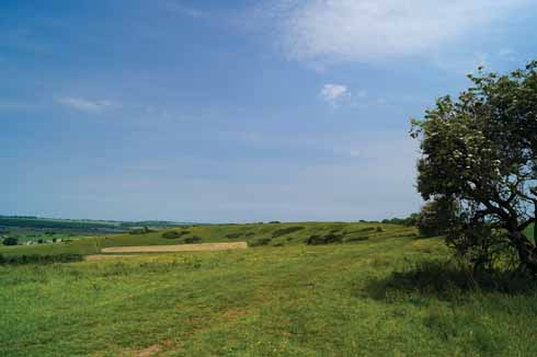
Ridgeway over Pentridge Down
Pentridge is in the north-east corner of Dorset where the county nudges against the Hampshire and Wiltshire borders and is surrounded by a landscape that is beautiful and isolated. To walk anywhere in the area is to be immersed in a terrain which is layered in history: the Dorset Cursus (a Neolithic causeway), Bronze Age round barrows, Neolithic long barrows, Ackling Dyke (a fabulously well-preserved Roman road), a medieval church and, right up to date, a World War 2 firing range. If this evocative atmosphere isn’t enough, then it is also a dream background for naturalists: nearby Martin Down, a National Nature Reserve, supports large numbers of rare chalkland butterflies, wild flowers and birds.
Derived from the Celtic pen (hill) and twrch (boar) – translated to ‘hill of the wild boar’ – the village of Pentridge was first recorded in the 8th century. However, it sits amongst the busy, bumpy landscape that many generations of earlier settlers tattooed on the land and can boast eleven round barrows within the parish, medieval field systems and the hugely important Bokerley Ditch, which is thought to have originated in the Bronze Age but continued to be adapted and used according to the defensive requirements of later periods – by the Romans against Saxon invaders and again when the Vikings attempted to conquer the Kingdom of Wessex – and now acts usefully as a visible divide between Dorset and Wiltshire.
One of the principal attractions of Pentridge is the fact that it is a cul-de-sac and can only be reached by a narrow lane, it is therefore situated away from significant traffic disturbance; just as the Roman Ackling Dyke enabled soldiers to by-pass settlements on their 22 mile route between Old Sarum and Badbury Rings, so the A354 does the same today, leaving Pentridge delightfully unspoilt by modern invasion.
St Rumbold’s Church, which serves Pentridge and neighbouring Woodyates, was recorded in the Domesday survey, although the current building dates to 1855. The literary links of Pentridge are recorded here with a memorial to the great-grandparents of the poet Robert Browning on the north wall – Robert Browning senior and his wife, Elizabeth, owned the Woodyates Inn, an important coaching inn on the London to Weymouth route.
Pentridge was known as Trantridge in Tess of the d’Urbervilles; it is where Tess first seeks the help of Mrs d’Urberville after the unfortunate death of her family’s horse.
A 19th-century resident of Pentridge was a character who could boast a life so filled with adventure that it sounds as if it were fictional. Cornelius Kerley was one of at least six children born to John and Mary Kerley and was baptised at St Rumbold’s in 1776. He left the agricultural life and, for some unrecorded reason, he was in Ireland when he was recruited and enlisted in the 54th West Norfolk Regiment of Foot in 1797, his first action being the suppression of an Irish rebellion. Cornelius served for twenty years, travelling the world and taking part in famous skirmishes of the time, from the 1801 defeat of Napoleon in Egypt to the 1807 campaign in South America. His service career finally drew to a close in 1817 after he was discharged and found unfit for service due to ophthalmia that he probably contracted in Egypt early in his career. He returned to Pentridge and married Mary Bright at St Rumbold’s in August 1818.
How to get there: On the A354 (Blandford to Salisbury) look for a right turning signposted to Pentridge. Follow the windy road (Morgan’s Lane) with care. Pass a cottage on the right and approach the T-junction at the start of the village and turn right (Earthpits Lane) – look out for a wooden post indicating the track to the church, hall and green on the right.
Parking & start: There is parking for church & village hall/green, or park outside the village with care. The walk starts from Earthpits Lane, OS ref 034176. If parking at St Rumbold’s, walk back down to Earthpits Lane and turn right. There a stile on the left side of the road
Terrain: Varied landscape. Some steady climbs, with mixed tracks, downland, woodland and fields. Some tracks will be muddy at times.
Distance: 4 miles
Maps: OS Explorer 118 Shaftesbury & Cranborne Chase
Refreshments: No pub or toilets in Pentridge.
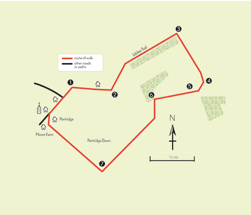
THE WALK
1 From Earthpits Lane ignore the turning to the church, walk along to the end of a high wall, cross the stile on the left into the field and then head diagonally to the top right-hand corner of the field and cross the next stile to follow a narrow tree- and bush-lined path which climbs steadily up Pentridge Hill. Cross the next stile into a field and continue uphill with the fence on the right towards the trees on Penbury Knoll.
2 Cross the stile. (NB: this route is overgrown and it may be necessary to cross through the clearing in the centre of Penbury Knoll). When you reach the fence on the far side, which is where the route joins the Jubilee Trail, walk round the back of the trees with the fence to the right and turn left to continue along the top of the ridge which is Pentridge Hill. Pentridge village is parallel behind a tree line in the valley to the left.
3 Continue along the top of the ridgeway, walking alongside the fence/hedge and then the path gradually begins to descent to a gate. Go through the gate and walk through a short tree-lined area until the path opens up in a field. Cross the field diagonally left towards a small wooded area and a fingerpost where the route turns right.
4 Follow the hedgerow down to where the path enters a wooded area (trees on the right) with open views to Bokerley Ditch on the left. The track then enters woods. Go through the gate and turn right, pass through the next metal gate and turn immediately left; the chalk path descends gradually to Bokerley Ditch and Martin Down. Just after passing through Bokerley Ditch, there is a bench on the right with wonderful views.
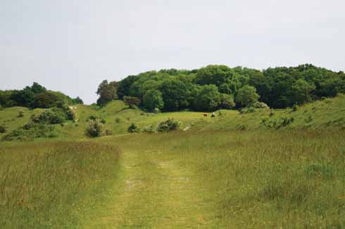
Bokerley Ditch towards Grim’s Ditch
5 There are lots of signs reminding walkers to keep dogs on leads. Martin Down is an area of 342 hectares owned and managed by Natural England and Hampshire CC which is home to an exceptional collection of rare plants and animals, including a number of rare or threatened species.
6 A short distance from the bench is a path which runs downhill alongside Bokerley Ditch. At the bottom there is a sign on the right with information about Martin Down. Turn left to follow the path which runs alongside the woods (there is a fingerpost indicating Jubilee Trail/Forde Abbey 90 miles!) Follow the straight path with fields on the right and woods on the left to a metal gate.
7 Go through the metal gate following the Jubilee Trail sign, continue straight on path, which rise along the right-hand edge of the field, until reaching a stileafter which turn immediately right, then through a metal gate with views of Pentridge Down and downhill past Whitey Top Farm to the road. Turn left back into Pentridge.
• For more information about Private Cornelius Kerley visit www.keepmilitarymuseum.org


