The Stour to the sea: part 2
Roger Guttridge, explores the middle section of the Stour and its connections to milling; pictures by Sylvie Guttridge
Published in November ’15
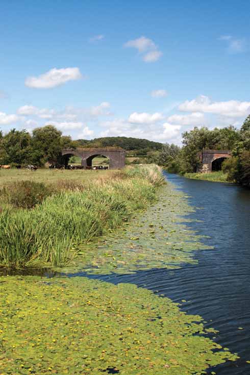
The railway bridge (not quite) over the Stour just beyond Sturminster Newton
The story of the Stour’s watermills is a catalogue of contrasts, and nowhere is this more evident than on the stretch from Fifehead Magdalen to Hinton St Mary and on to Fiddleford. From the busy working (albeit now diesel-powered) West Mill near Stalbridge, Dorset’s biggest river passes the redundant but perfectly preserved King’s Mill at Marnhull before flowing down to the sad ruin that is Cut Mill at Hinton St Mary. It was not always so. Historic buildings consultant Carole Ryan-Ridout once described Hinton’s mill as ‘Constable-like in its visual quality’. In a prize-winning essay in 1959, H S L Dewar said it was ‘most picturesquely situated’ and ‘still workable with a little repair to the water wheel’. It would take more than a ‘little repair’ to render it workable today. Years of vandalism and a fire in 2003 have reduced this 18th-century gem to a broken shadow of its former self. This fire was not the first. An earlier blaze in 1817 reduced both mill and miller to ruin.
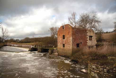
Cut(t) Mill, now a rather sad shadow of its former self
Cut Mill’s history is well charted. The Domesday Book of 1086 lists Hinton St Mary as one of 226 working mills in Dorset and, given that the Romans introduced watermills to England and there was a Roman villa half-a-mile up the hill, it’s possible that it dates back almost 2000 years. In 1098 it was one of three Hinton mills owned by the Abbot of Glastonbury.
The first OS map, published in 1811, shows the mill and miller’s cottage and spells it ‘Cut Mill’, a single ‘t’ being the norm until recent decades, when ‘Cutt’ has become universally popular. The name comes from the Middle English ‘cut’, meaning water-channel.
Owner Anthony Pitt-Rivers believes that full commercial milling stopped as far back as the 1920s, although the Hunt family, who were tenants from the 1860s, were still grinding corn for local farmers after World War 2. ‘It was a very underpowered mill and it wasn’t modernised at the end of the 19th century, as other mills were,’ Mr Pitt-Rivers told me for an earlier article for this magazine in 2007. ‘The head of water is very low compared to Fiddleford and Sturminster mills.’
At that time there were ambitious plans to rebuild Cut Mill as holiday accommodation with electricity generation by water power, although stabilising the mill platform would have been a costly prerequisite, while ground floor occupation was not an option due to the inevitability of flooding. The scheme has so far not materialised.
Author Monica Hutchings nominated Sturminster Newton as ‘the capital of the river and a place whose history and being is at one with it’. As if to welcome the Stour to its capital, two huge lumps of masonry perch imposingly on opposite banks. In the days of steam they supported the bridge that carried the trains of the Somerset and Dorset Railway into the market town from the north-west. The iron centrepiece is long gone but the flood arches survive as a tribute to a past age.
Beyond the remains of the railway bridge is a lesser but prettier crossing point. Colber Bridge is equipped to carry only people and livestock, and it is tempting to think that two centuries ago the young William Barnes (born 1801) might have crossed the river here on his daily journey from Bagber to the Sturminster schoolroom, where he took the first steps on the path to a distinguished career as a dialect poet, philologist, schoolteacher and clergyman. However, the bridge is dated 1841 and the 1811 Ordnance Survey map indicates there was no predecessor there then, so Barnes presumably crossed downstream at Sturminster Mill. He often refers in his poems to the ‘cloty’ Stour – cloty being a dialect reference to the yellow water lilies that thrive in these waters.
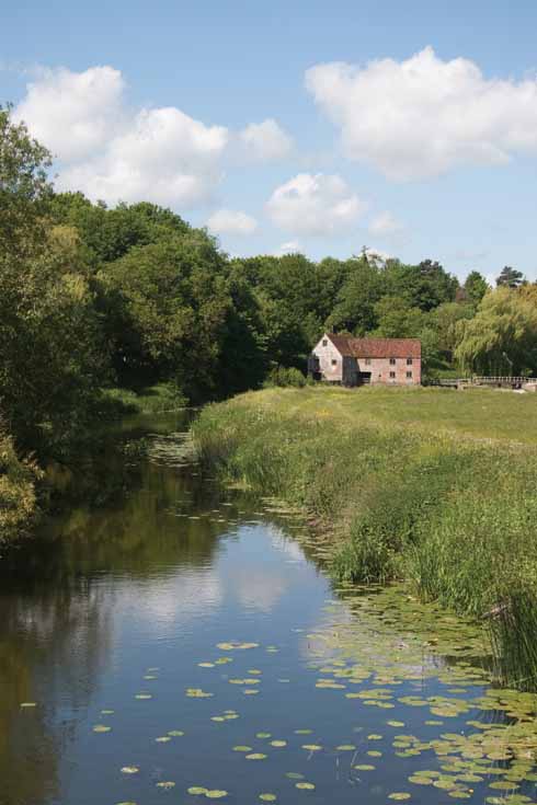
The iconic riverside scene that is Sturminster Mill
The Stour at Sturminster boasts more literary connections than any other short stretch of Dorset river. As well as the Barnes connection, Thomas Hardy, Robert Young and, more recently, Rosemary Ellerbeck have all lived within sight of the river. Ellerbeck, a best-selling novelist, who also writes as Nicola Thorne and Katherine Yorke, lived in The Row and later Southbank from 1988-2002, writing many books, including the six-part saga The People of This Parish, set in Wenham, which is based on Sturminster. She now lives in Plymouth.
A few yards downstream, a plaque on the wall of Riverside reminds us that Hardy and his first wife, Emma, lived there from 1876-78 – a period the novelist and poet later described as their ‘happiest time’. Hardy wrote The Return of the Native there and the location inspired poems such as ‘Overlooking the River Stour’, ‘A Two-Years Idyll’ and ‘On Sturminster Foot-Bridge’ – a reference to Colber Bridge.
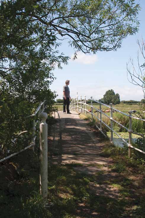
Colber Bridge, erected by J Conway in 1841 and featuring the author gazing down the river
Hardy’s landlords at Riverside were the Young family and Robert himself later lived there and died there in 1908, aged 97. Young was a tailor but is remembered for his humorous verse in the Dorset dialect. Using the pseudonym Rabin Hill and describing himself as an ‘Olde Dorset Songster’, Young published some of his works, most notably his amusing account of a country bumpkin’s encounter with Sturminster’s first steam train – Rabin Hill’s Visit to the Railway, What He Zeed and Done and What He Zed About It.
Adjoining Riverside is the recreation ground. In my childhood, a rustic shelter overlooked the river, its seats offering a choice of views – the latest sporting fixture or the more picturesque vista of the Stour, the overgrown island which divides the river at this point and the meadows beyond. Trees now partly obscure the view from here while the rustic shelter has been replaced by a more robust if less aesthetically pleasing successor.
Downstream from here, I and friends whiled away many a 1960s summer day swimming in the river and sunbathing on the bank, whose slope also made this an ideal location for the river sports that were once a popular feature of carnival week. Four strands of barbed wire and a profusion of thistles, nettles and cow parsley are major deterrents to recreational activity today.
Sturminster Mill is the town’s pièce de résistance, and one of few on the Stour that is still in working order, although its raison d’être now has more to do with tourism and picture postcards than the grinding of corn. The present building – open to visitors four days a week from Easter to September – dates mostly from the 17th and 18th centuries but there has been a mill here for at least 929 years, as it too was mentioned in Domesday Book.
Both mill and the low-lying meadows opposite have always been prone to spectacular flooding, and grooves cut in the stone porch show the water levels reached in 1756 (5ft) and 1979 (4ft 6in). No fewer than 20 floods occurred in 1926 alone, washing away the steps of the bay and boards from the hatches.

Many a Dorset bridge bears a similar sign threatening transportation to Australia as a punishment for wilfully injuring the bridge
Sturminster’s ‘hoary bridge of stone’, as Barnes called it, was built in the 16th century but has a date-stone from 1820, when it was widened. The sign offering a ticket to the colonies to anyone damaging the bridge is also 19th-century. The high outcrop of rock overlooking the bridge is known as Sturminster Castle, and the site was well placed to guard the river crossing in troubled times. The stone ruins on the hill today are of an unfortified 14th-century manor house, described by Henry VIII’s topographer John Leland as ‘portly and strong, able and meet for a knight to lie in’. The ruin stands within a crescent-shaped Iron Age earthwork and there may have been fortifications here at some time in the distant past. Legend has it that Saxon kings lived here in a 10th-century manor house said to have preceded the present ruin.
The low-lying Bull Inn nearby is among the first buildings to be flooded when the Stour bursts its banks. The water has been known to lap the spirits bottles on the optics shelf. Across the road is the stretch of river where, during the ‘big freeze’ of 1962-63, a hindquarter of beef was roasted on the Stour, emulating the efforts of an earlier generation, who roasted an ox near Colber Bridge in 1895. There was also skating, ice hockey and floodlit dancing in 1963.
After passing St Mary’s Church and Piddles Wood, the Stour reaches Fiddleford, a hamlet with a history out of proportion to its modest size, some of it provided by my own maternal ancestor Roger Ridout, who led the local smuggling gang and regularly hid his contraband at Fiddleford Mill more than 200 years ago. As at Hinton and Sturminster, there has been a mill here since at least 1086. It was still a working mill in my youth, operated by Rupert Rose, one of the last true dialect speakers as well as the last miller. His house was historic Fiddleford Manor, an English Heritage property completed about 1370 and famous for the timberwork above the great hall and solar, regarded as the most spectacular in Dorset.
The mill buildings are silent now, and gone too is the poultry flock, including Muscovy ducks and hissing geese, that roamed freely around the yard half-a-century ago. Humans also flocked to Fiddleford on hot summer Sundays, walking over the fields from Sturminster to swim and paddle in the river and rolling bay and sunbathe and picnic on the bank.
Today water power is being used again – to generate electricity. The turbine’s design allows fish to swim safely downstream and the weir has been modified to make it easier for fish and eels to migrate upstream. A few yards down from here, the Darknell Brook becomes the latest tributary to add its water to the Stour. ◗


