The Dorset drive: Up the Frome and down the Piddle
Matt Wilkinson follows two of Dorset’s most significant river valleys
Published in January ’15
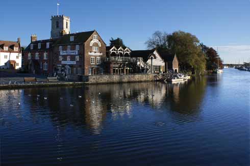
The Quay at Wareham in a rather less wintry moment
If the Stour drains much of north and east Dorset, most of the water that descends from the Dorset Downs in the centre of the county finds its way into the Frome or the Piddle. They both flow into Poole Harbour at the Wareham Channel, but on their journey they have carved distinctive valleys which provide a lovely landscape for a drive.
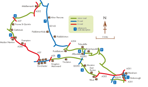
Distance: About 70 miles
Start: The Town Cross in Wareham. OS reference SY923874; postcode BH20 4NS.
Maps: OS Explorer OL15 (Purbeck & South Dorset) and 117 (Cerne Abbas & Bere Regis). Landranger 195 (Bournemouth & Purbeck) and 194 (Dorchester & Weymouth).
Refreshments: On the route at Wareham, Stoborough, East Burton, Dorchester, Maiden Newton, Cattistock, Piddletrenthide, Piddlehinton and Puddletown.
[Milometer readings are given in square brackets. They should be generally reliable, but milometers do vary slightly.]
1 Head down South Street and cross the Frome on South Bridge, built in 1927 when the bottom of South Street was re-aligned; much of the stone from the old bridge went to build the porch at Trigon, a country house to the north-west of Wareham. Cross the water-meadows, enter Stoborough and turn right just after its primary school [0.7]. At the end of the road turn left onto the Wareham by-pass then almost immediately right, signed to Creech, Steeple and Kimmeridge. Take the first turning on the right, Holme Lane [1.2]. Follow this over a bridge over the Swanage branch line and past Holme Priory across its park on the right to a cross-roads [3.4].
2 Turn right, signed to Wool, cross the Frome by Holme Bridge, where a substantial skirmish took place during the Civil War, and a level crossing, and turn left on the A354 [4.5]. At the first roundabout [7.3] bear left towards Wool, crossing Wool Bridge and passing Woolbridge Manor on the right; this was where Tess of the d’Urbervilles spent her disastrous honeymoon night with Angel Clare. Just before the level crossing, turn right [7.7], signed to East Burton and Moreton. Follow this road past Winfrith Technology Centre, formerly the atomic energy research establishment, on the left, and Moreton House, home of the Frampton family, on the right. Entering Moreton, the small graveyard where Lawrence of Arabia is buried is on the left.
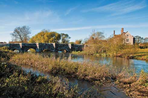
Woolbridge Manor with the bridge over the Frome
3 As the road swings to the left in the middle of the village, signed to Crossways and Weymouth [11.1], worthwhile diversions to the prettiest ford across the Frome and to see Laurence Whistler’s astonishing engraved windows in the parish church can be made by carrying straight on. Following the road round to the left, though, at the end of the ancient wall on the right, fork right. At the next T-junction [12.1], turn right, signed to Affpuddle and Bere Regis. The Frome hereabouts splits, so cross two bridges over it in quick succession, then pass watercress beds that are watered from the river on the left. At a cross-roads at the top of a slight rise [12.7], turn left. Pass Pallington Lakes on the left – once a fish farm and fishing lake, it is now home to Sculpture by the Lakes, sculptor Simon Gudgeon’s outdoor sculpture park – and continue through Tincleton.
4 Stay on this road past Kingston Maurward College on the left to reach a roundabout [18.8] and go straight across, towards the centre of Dorchester. Cross the Frome again at Grey’s Bridge and continue straight up to the Top o’Town roundabout [20.2]. Turn right here and follow the A37 through water-meadows, past the course of a Roman aqueduct – an incredible piece of engineering – on the left, past Bradford Peverell and Stratton, and through Grimstone. Just after Grimstone, fork left onto the A356, signed to Crewkerne [24.8]. Go through Frampton, whose name is derived from that of the river, and continue to Maiden Newton.
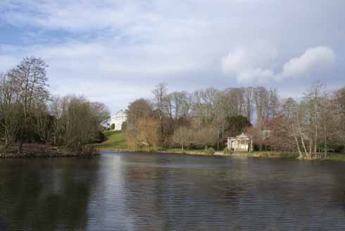
Kingston Maurward
5 In the middle of Maiden Newton, where the road bends left with the stump of the old village cross on the right, turn right [28.3], pass the war memorial on the left and take the next fork on the left into Cattistock Road. In Cattistock go sharply round to the left, followed by more gentle bends to the right. Soon after leaving the village, turn right, signed to Chantmarle, Chalmington and Frome St Quintin [30.2]. Take the first turning on the left [30.5] and stay on this lane through Frome St Quintin to reach the A37 [33.3]. Turn left and shortly take the first on the right, signed to Batcombe and Minterne Magna.
Dorchester’s High Street West
6 Evershot, where the Frome rises, lies away to the west, but now it is time to head east, across the head of the Sydling valley and through the Cerne valley, which is reached at a T-junction with the A352 [38.1]. Turn left and take the first on the right after entering Middlemarsh [39.7] Go straight across a cross-roads and follow the lane to a T-junction [40.7]. Turn right, signed to Buckland Newton. At the next T-junction [42.3], turn right, then look out for a turning on the left onto the B3143, signed to Buckland Newton and Dorchester [43.0]. The next river crossed is – confusingly – the River Lydden, which flows north to join the Stour, but then the road enters Alton Pancras. The Piddle rises just to the west and at the far end of the village flows along the right-hand side of the road.
Maiden Newton
7 Follow the road through Piddletrenthide and Piddlehinton and soon after a sharp right-hand bend, turn left, signed to Puddletown [50.2] Pass Waterston, which was Upper Weatherbury Farm, home of Bathsheba Everdene, in Far from the Madding Crowd, and Druce, which served as Lower Weatherbury Farm and where Roman remains have recently been found. Reaching a roundabout [52.6], turn right and go straight across the next roundabout to enter Puddletown, crossing the Piddle on the way. At the T-junction with traffic lights [53.2], turn left and follow the road past Athelhampton House and the Martyrs’ Museum into Tolpuddle. Just past the Green and the Martyrs’ Tree, turn sharp right [55.6], signed to Southover and Affpuddle.
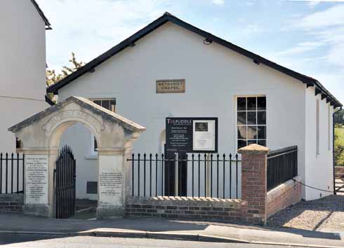
The Methodist Chapel in Tolpuddle
8 Like the Frome earlier, the Piddle divides here, so go over a number of small bridges before the road bends sharply to the left and leads through Affpuddle to a T-junction [57.0]. Turn right, and at the top of the hill first left. Go through Briantspuddle, Sir Ernest Debenham’s model village with its oh so neat houses contrasting with the angular war memorial designed by Eric Gill. Go across the cross-roads in the middle of the village [57.7] and continue to another cross-roads [58.9], where turn left, signed to Turners Puddle and Bere Regis. Cross the Piddle again by Cecily Bridge and reach a T-junction [60.5].
9 Turn right and very shortly fork left, signed to Bere Heath and Hyde. Go straight across the next cross-roads [61.2] and cross the Bere Stream, a tributary of the Piddle. Once again, the main river is divided into two streams and is crossed by two bridges. Reaching a T-junction [64.2], turn left, signed to Worgret and Wareham. At the end of the road [67.8] turn left and at the roundabout turn left onto the Wareham by-pass, which is elevated above the Piddle water-meadows and crosses the main stream of the river. At the next roundabout [69.1], turn right, cross the Piddle again on North Bridge and head up into Wareham and the Town Cross [69.5]. ◗


