The Dorset Walk 1 – Spetisbury Rings, the S&D and Tarrant Abbey
Matt Wilkinson and Dan Bold explore the landscape south of Blandford
Published in April ’14
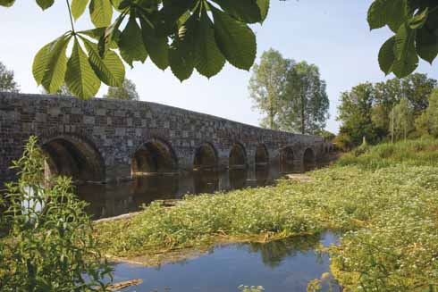
The walk starts close by the River Stour, which is crossed by nine-arched, 15th century Crawford Bridge, widened in 1819 and now Grade I listed.
The walk then goes further back into history when it follows the bank of Spetisbury Rings. As this Iron Age hillfort consists of only one ditch and rampart, it may not have been very effective, despite its impressive appearance, or possibly the Romans arrived before its building was completed. The eastern edge of the Rings is cut through by the old line of the Somerset & Dorset Railway; 19th-century railway-builders were not particularly fussy about historic monuments.
After crossing the Stour and briefly following its tributary, the Tarrant, the walk passes Tarrant Crawford. Its St Mary the Virgin church is notable for its medieval wall paintings and because Queen Joan of Scotland, daughter of King John, was buried in its churchyard.
THE WALK
1 Walk back over Crawford Bridge, cross the main road carefully and walk straight ahead up Louse Lane. In about 80 yards, turn right onto a paved path, then almost immediately cross a stile on the left and turn right to follow the right-hand field-edge. In the first corner, continue through a small patch of woodland and emerge with the bank of Spetisbury Rings straight ahead. Scramble up the bank and turn left to walk along the top of the rampart to a trig point. Continue for a further 150 yards to where the rampart reaches a dip. Turn left here to walk straight across a field to a lane.
2 Turn left and continue for almost a mile to South Farm, opposite which turn right and walk straight across an open field to a gap visible on the far side. Continue in the same direction across the next field, aiming for a gate just to the left of the large tree on the skyline. Follow a track down the right-hand edge of the next field and straight through North Farm’s buildings to emerge onto a track.
3 Turn left, and in about 80 yards, right on a track that curves through the left-hand field-edge. Stay on the track across the next field, and again in the field after that, where it runs alongside woodland on the left. At the end of the wood, continue straight ahead along the left-hand edge of the next field, and bear right in the field after that to cross it to a gate a little to the left of its furthest corner. Here turn right on an enclosed path. Continue straight ahead at a crossing as the path becomes a track, which reaches another crossing.
4 Here turn right and walk down the paved drive of Gorcombe Farm. Pass the farm and walk straight ahead onto an enclosed path. It becomes a track and leads through the buildings of Manor Farm. Continue as it rises slightly to reach a gate. Beyond the gate, follow a woodland path which becomes an unpaved drive, then a paved drive leading to an old railway bridge. Just before the bridge, turn right up some steps and right onto the old track-bed. Charlton Marshall is to the left. Just after a bridge in about ¾ mile, turn left down to a lane, where turn right and walk down to the main road.
5 Cross with care onto a track which leads right through the buildings of Clapcott’s Farm, leaving on a path that runs down the left of a double garage. The path becomes a raised walkway and emerges onto a space in front of another double garage. Here turn right over a little bridge, then left hard alongside the wall of a house on the right. Cross another bridge and continue on a path through woodland to reach an open meadow. Walk straight across it to a bridge visible on the far side. Do the same in the next meadow, this bridge having a metal gate in front of it.
6 Walk up the drive of Keynston Mill to just past the first gate, where turn right, then immediately right again on a path that leads back towards the water. Follow this until it eventually bears left at the end of an open field, with the river (now the Tarrant, just before it joins the Stour) close on the right, goes under some power lines and reaches a main road. Go almost straight across to a paved drive. Where the drive forks, take the left fork, then follow it round to the right to reach a junction by the church.
7 Here turn right and, in a few yards, left through a gate. Follow the path as it climbs diagonally up the hillside with the buildings of Tarrant Abbey Farm below and to the right. Almost at the top of the rise, go through a gate and continue straight ahead, along a line of telegraph poles. On the far side of the field, go across a road, through a gate and down the right-hand edge of the next field. Cross a drive onto a broad grassy track, which passes under some power lines, then swings left to a gate and stile. Cross the stile and in a few yards turn right into an open field and follow its right-hand edge round two sides to the far corner, where turn right on the road that leads back to your car. ◗
Distance: About 8 miles.
Terrain: Undulating route with no significant climbs. Generally good going underfoot, but the water-meadows of the Stour are damp except after an extended dry spell.
Start: Park carefully on the verge beyond Crawford Bridge. OS reference ST919022. Postcode DT11 9HY.
How to get there: Turn north-east off the A350 at the cross-roads at the south-eastern end of Spetisbury and cross Crawford Bridge.
Maps: OS Explorer 118 (Shaftesbury & Cranborne Chase), OS Landranger 195 (Bournemouth & Purbeck) and 194 (Dorchester & Weymouth).
Refreshments: Spetisbury, DT11 9DJ, Woodpecker (woodpeckerspetisbury.co.uk); Charlton Marshall, DT11 9NH, Charlton Inn (charltoninn.co.uk)
Thornicombe, DT11 9AG, Gorcombe Café (gorcombe.co.uk)


